Monday, February 23, 2015

Pre-20 Mule Team 100 - I haven't done enough jitters

Training didn't go super smoothly for this year's 20MT. I started out feeling pretty good about it - had Roop along as a pony horse (as "Plan B, Just In Case"), both pones were working well, and everything was following the conditioning regime I'd outlined for us.

And then just as I was supposed to ramp up to a 20 mile "hard ride", the monsoons struck:


I don't actually mind riding in the rain, but I do mind taking the horses out on steep clay trails that become slick as snot – a great recipe for a slip and pull – so opted out that weekend. It wouldn't be the end of the world - there'd be plenty of other opportunities... maybe I could sneak in a good ride one weekday morning? (not)... 

The following weekend we were due to go up to Reno for a good training/trotting ride - 20 miles of similar terrain to 20 MT which I thought would be just the ticket. 


Bedell Flat - the first loop on Rides of March endurance ride. It doesn't look
like it on the map, but there's actually 2,000 ft + of climbing on this loop.


But in the event, taking along a pony horse didn't work out so well and trying to get three horses to settle down and stop trying to out-perform each other proved beyond Renee and my capabilities, so we ended up with a lovely not-so-trotty 20 mile training ride (and it was so great to see Renee and get to spend a quality day with her, instead of the "hi/bye" type interactions we've been having for about the last 18 months). Both of mine looked like they hadn't really done anything at the end, which was gratifying, but since they hadn't really done anything (unless you count yanking my arms out of my sockets trying to keep them both under control on the way back across the valley) I'm not sure how useful that actually is. If nothing else, it's hours out on the trail, right?

Before we got on the proper trotting section, when everyone was
still keeping it together and pretending to be adults

Starting to deteriorate. Renee finally gave in and switched all Roo's tack
onto Bite and rode him. I'm not sure it was any better  (actually even more
exciting for him, by the looks of things) and Roo certainly thought having less
encumbrances was a better idea on the way home as my two did their
best race horse impersonations all the way back across the valley.


It was a bank holiday weekend, so luckily I'd have Monday to get in that last 15 mile trotting ride to put the icing on the cake, right? Wrong. Apparently if you push too hard, you get nowhere and my body suggested that stopping, please, might be nice, so I tried to stop for a couple of days. Unfortunately, stopping isn't one of my strong points, so even prone and doing little, the brain is still going mile-a-minute and keeping the system online, ready, just in case. 

Stop please. I want to get off.

I did get Finn clipped. He was only about five months overdue. No foo-foo cut for him, given the amount of matts - just a convict cut for that dog-on-stilts look (as Ann calls it):

still needs finishing off, but for fun, I opted to only cut one side to start with 

Sporting that raffish, dog-about-town look

Dog-on-stilts the following weekend when he was all done.
I actually really like him in a short cut like this (once you get
over the initial shock). He's very sleek and slinky looking. 


The following work week turned out to be the busiest in months, culminating with not leaving my office until 11 pm* on Friday in an effort to finish up a project due on Monday (*means I get home after midnight). But that at least meant that I didn't have to work over the weekend so would have more than enough time to go out with Uno on Saturday (prospective buyer wanted to meet and ride him) and get in a ride on Fergus on Sunday. Only, remember the previous weekend when my body said "enough!"? It did it again. I spent a good portion of Friday night/Saturday morning in the bathroom, not having the time of my life. You know you've been working too hard and spending too much time doing GIS when, upon returning to bed and trying to sleep, your brain keeps trying to uncheck the box on the "tummy ache layer" to turn it off (it doesn't work, btw, it keeps turning itself back on). Not good. 

I did get the ride done with Uno, but getting him ready and riding about wiped me out (although, of course, I felt pretty good the whole time I was riding - go figure, what does that tell you?). So back to bed I went and stayed there all day Sunday. No eating (within 36 hours I'd dropped 4 lbs). No riding. No packing. Do not pass Go. Do not collect £200. 

It's Monday now and my body still hates me. Food is going in and staying there, gingerly, but I feel pretty crappy if I try to do more than just sit. Even my teeth hurt right now. So I'm taking it super-easy as much as I can. I don't leave for Ridgecrest until Thursday, so am doing slow-motion packing and pft is helping a bunch for which I'm very grateful. 

Fergus and I on the Cliff Trail at Joshua Tree a couple of days after Christmas

Fergus is fat and happy, not knowing what's ahead. I bought some Freeform panels from someone (in England of all places), so have been moving pad inserts around and think the new set-up should be better for his back. He wasn't getting sore, per se, but has some sort of callousy-areas that needed different padding. He's only done 35 miles in them so far, but I think they'll do the job - and they velcro-on/velcro-off, so if they appear to be doing more harm than good I can whip them off very easily, mid-ride. 

The underside of my Sensation has "loop" velcro on the front, so they stay put at that end. Unfortunately the back part isn't as sticky, so my job sometime before Thursday is to attach (and probably sew) some sticky-backed loop velcro in the loin area of the underside of the saddle to keep them from shifting each time I tack up (and given how tall he is, trying to get things straight on him when they're way above your head is no mean feat). The extra padding (esp. the first time I tried the panels out, without first removing the mega-inserts from the Sensation pad) make him about 17+ hh, which is ridiculous. 

As far as "special treatment", I had a bucket of E-Se-Mag supplement that I never got around to feeding to Roo, so both of them have been getting a couple of scoops of that in a yummy mush. They both think this is a fine idea and are very attentive in the mornings. I'm not sure Fergus really needed it - it was bought primarily to help Roo with his crampy back end - but it doesn't hurt as far as I can tell. 

And the very good thing is, during all this Roo has been worked very nicely so is up and running and ready to go to whatever ride I choose to take him to - without any of my usual concerns about lack of riding and under-conditioning. I'd say he's probably as fit as he's ever been. 


So to sum up, our total conditioning (especially aimed at getting ready for 20 MT) for Fergus (and Roo, with the exception of the 45 miles at Christmas) has been:

  • 45 miles - Christmas week at Joshua Tree/Catalina State Park, including much walking in sand washes, and one hard and fast 13 miler keeping up with pft on the mtn bike.
  • 10 miles - local trails, mostly walking, but with the Powerlines thrown in
  • 11 miles - singletrack trails between Auburn Lake Trails and the Middle Fork, up and down, up and down, starting to add in good trotting, although not continuous
  • 14 miles - Rock Creek dirt roads - hardest, fastest to date. Route was picked for maximum continuous trotting and we certainly got that in. Roo did some astonishing trot moves that I'd never in a million years let him do with the extra weight of a rider. 
  • 15 miles - singletrack trails between Auburn Lake Trails and the Middle Fork, up and down, up and down, Sally rode Roo and kept us to her rolicking Tevis-ride speed (note to self - I am much more cautious than Sally when it comes to riding rough terrain :)  )
  • 0 miles - monsoons hit
  • 21 miles - Bedell Flat with Renee, good length, some overachiever trotting towards the end, some good speed walking (doing a Walk-off between Fergus and Bite), some sand, some climbing. Two weeks until Ride Day.
  • 0 miles - bleahs, so Fergus is what he is, fitness-wise.

I am, admittedly, relying very heavily on his existing base, and the fact that we ride slow, and the fact that the last ride he did was a stellar Tevis, and the fact that the ride itself isn't too hard.

And I'm also cognizant of the fact that, no matter what I do, I always feel under-conditioned, so I can never win.

But mostly, Fergus and me (and Spike, since he gets to come along as ride dog and all round entertainer - and company for the long drive up and down the Central Valley) will have an excellent adventure, get to spend the day with Kaity (always a pleasure and my favorite 100-mile ride buddy), and hopefully we'll get to the finish, learning a bunch in the process.


Epilogue: after 2.5 years, my braces come off the Wednesday after 20MT - woot!!


Friday, January 16, 2015

Tevis Trail Pre-Riding

A friend contacted me last spring to ask about Tevis pre-riding. She wasn't familiar with the trail at all, so wanted to know about access points, parking, horse water on the trail, etc.  I've been pre-riding the Tevis trail for over a fifteen years - sometimes just for fun, sometimes to get ready for the ride itself, so I typed out everything I could think of, including mini-maps of "where the trail went" (in certain less-obvious spots). I’m not sure how much use my grotty maps are, but hopefully they give some idea of what the trail does.

Disclaimer: obviously this is my take on the trail and what needs to be pre-ridden. Other people may have different ideas.


Mileages shown are rough.


Obviously, there's more information on the Tevis website,
including historic notes on the trail by Hal Hall
and an overall map of the entire trail. 


Contact the Western States Trail Foundation (WSTF) office
for specific and uptodate details on the trail: 
530.823.7282 or wstf @ teviscup . org (close up spaces).


Tevis Trail Pre-Riding:

You mostly split the trail into three sections:

  1. Robie Park to Red Star Ridge/Robinson Flat (Mile 0 to 28/36)
    The High Country - no pre-riding needed 
  2. Robinson Flat to Foresthill (Mile 36 to 68)
    The Canyons - some pre-riding needed so your horse knows what’s coming. 
  3. Foresthill to Finish (Mile 68 to 100)
    CA-Loop singletrack - most of your pre-riding will be here.


1. Robie Park to Red Star Ridge (Mile 0 to 28):

I have never pre-ridden this section and I don't really think it's worth the trouble, frankly. Moving rigs is all but impossible unless you have a really helpful assistant who’s willing to drive you up to Tahoe, then drive all the way to Robinson Flat to meet you = a very long boring day for them. I was happy to have this part of the trail as a surprise (I adore the Granite Chief Wilderness Section and it was lovely to see if for the first time "on the ride"). Water is limited (some at the beginning near Squaw and in Granite Chief Wilderness, but none from Lyon Ridge to Robinson Flat)

That said, if you do want to pre-ride parts of it:

Robie Park to hw89 (Mile 0 to ~6)


Park: at Robie Park (very long slow drive in), ride the trail to hw-89 and return.
Or park in the turnout at hw-89 (see blue arrow on map below) and ride up to Robie Park and back.

Trail: I don't believe this trail is marked "to Robie"/"WST", so you'd need to follow GPS. There are turn-offs, so not self-explanatory. There are two sections with some short, low wooden bridges that cross boggy areas. These shouldn't be a big deal for a seasoned trail horse.

Water: 

  • Not a lot of water on the trail - a couple of small trickles earlier in the year.
  • You might be able to slither down to the river at hw-89 with a bucket.
  • There is a water pump at Robie Park. 


Your horse is so hyped and everything is such a blur and it's dark for the first 15 mins or so, and you're in the long train of riders so it's not like a) you could get lost or b) you see much, or c) you can really control speed much. So all in all, not worth the trouble.

The only thing probably worth doing on pre-Ride Friday is to ride up to the start and go the first couple of 100 yrds down the trail to familiarise you with the route. Do this as a leg-stretcher pre/post vetting. Also inspect whichever pen you're going to be in.  It's very very dark on Saturday morning and there are tree stumps etc to trip over, so it's good for you and your horse to at least know that part.

Map showing the trail where it “crosses” hw-89.
The trail goes under the road next to the bike path then goes alongside the south side of the road behind the barrier over the river on the bridge. Park in the turn out indicated by the blue arrow. Or just visit there and inspect the trail layout on foot.
(If you wanted to go up and camp for the weekend, there's a fair few other trails out of Robie Park with some nice riding. You can camp at Robie Park for $15 a night/horse (see: http://www.robiefoundation.org/park.htm). Trail map here: http://www.robiefoundation.org/trails.htm)


Hw-89 to Bottom of Squaw (Mile ~6 to 8):


Park: at the HW-89 turnout (see blue arrow on map above) and ride the trail west along the ridge south of Squaw.

Alternatively, park in the parking lot at Squaw and access the trail from there (I have never done this, but believe it's perfectly legal).

Trail: This trail *may* be marked "WST", but I'm not 100% sure. Probably need to follow GPS. There are turn-offs, so not self-explanatory.

Water:  There is at least one creek crossing about half-way along for horse water 
(can’t remember exactly – I’ve put a couple of lil blue crosses where I think it might be, ish):

Map showing Hw-89 Crossing to the Climb in Squaw Valley

Squaw to Red Star (Mile 8 to 28):


Park: at Squaw Valley.

It's probably worth checking with the WSTF office (530.823.7282 or wstf @ teviscup . org [close up spaces]) regarding this stretch of trail, as I'm not sure about the actual legality of riding across Squaw Valley property.

Note from a friend: "Squaw is private property and the trail access is somewhat of a "as long as you're not in the way" type of thing.  I know the actual riders have to sign a release form in order to cross the property (in the pre-ride packet)."

A couple of years ago they were doing work on the westerly ski-slope area and didn't want people going in there because of construction equipment, etc. Don't know if this still holds true, but worth checking. For example, during the ride, we had to cross over some straw-berm-things that seemed to be covering electrical cables. One horse in steel shoes (ridden by Hal Hall) trod on the berm and got an electric shock (transferred to the rider). So take care.

Trail: Provided you can access the trail through the Squaw Valley resort, you can follow the trail all the way to Red Star and Robinson Flat.

This trail *may* be marked WST, but is not self-explanatory and there are turn offs, so again, GPS track needed.

Water:  There is water along the way in Granite Chief Wilderness, but nothing along Lyon Ridge (very dry). Allegedly there is a spring at Red Star, but we looked for it a couple of years ago and didn't find it.


2. Red Star Ridge to Foresthill:

Red Star to Robinson Flat (Mile 28 to 36):


Park:  at Robinson Flat. Camping is free overnight with horses. They have a pit toilet and a hand-crank pump in the meadow for horse water.

Trail: This is basically a hard-packed dirt road for 8 miles. Not worth riding, but if you’d like to see it, unhitch your truck and drive it. There are some pretty views and the road is rough (but they get trailers in there, so not awful). You need to be aware of one turn-off (left [north], going backwards up the “trail”) close to Red Star (see grotty map below).

Water:  None (except for the elusive Spring north of Red Star that we didn’t find).

Really grotty map, showing the Red Star Ridge Vet Check Area:
Red = Red Star Vet Check (wide spot in road, sort of four-way intersection).
Yellow = Tevis Trail (west goes to Robinson Flat, East goes (eventually) to Cougar Rock)
Blue = Road you need to turn off of. The road from RF continues on this blue road. Turn left to go to RS
Green = Soda Springs Road – the road goes from Robinson Flat all the way to Soda Springs.
Very rough past Red Star Vet Check (also shown in green, spur road west of RS)


Robinson Flat to Foresthill (Mile 36 to 68):


Park:  at Robinson Flat. Camping is free overnight with horses. They have a pit toilet and a hand-crank pump in the meadow for horse water. Fire rings, picnic tables…

Our usual MO is to pick a weekend in June and go up there on Friday and camp, and then ride from RF to FH in one go (32 miles) on Sunday.

Alternatives:

  • Only ride as far as Last Chance. Bad idea – paved road from Foresthill to Last Chance takes HOURS. Very very twisty. Last few miles is dirt.
  • Only ride as far as Deadwood, then ride the 8 miles out on DW Road to paved Foresthill Road (a long dirt road, probably not worth the trouble, but an option with a lame horse)
  • Only ride as far as Michigan Bluff – avoid the final Volcano Canyon. Again, not usually worth the trouble – it’s much easier to park a trailer/support vehicle in Foresthill, than to drive down to MB – and it’s only another six miles from MB to FH. Volcano Canyon is the smallest one. 

As far as trailer-pooling, there are two ways:

  • Leave a car in Foresthill (near the school?) on the way past. Then get a really kind friend to drive your rig to FH after you’ve departed and leave it for you in FH and they go home in the car
  • Leave a car in FH on the way past. Then have at least two more riders than there are trailers. When you arrive in FH, one person stays with all the horses (we cache horse food and water beforehand), while the other two take the car to go and fetch the trailer at RF. This makes for a very long day, esp. if you leave late to start with, but is perfectly doable. 

Camping for the weekend: there’s a really pretty  5 mile loop out of the RF meadow that takes you up the ridge to the south of RF – excellent views - and you can visit the Look Out Tower (the ranger is very nice and likes visitors) to look over towards Foresthill. You come back down to the meadow on an alternate Tevis trail (last used in 2009?). It’s a nice place to camp for a couple of nights prior to your Big Preride.

Map showing Robinson Flat Vet Check/Camping Area

Water:  The longest waterless stretch is from Robinson Flat to Last Chance ~14 miles. If it’s ridiculously hot, we have cached water (in gallon ziploc bags so we could stuff them in the saddle bags when empty) at the turn off to Dusty Corners which is accessible by vehicle from Robinson Flat.

Otherwise, there is water at:

  • Robinson Flat (hand-operated pump in meadow)
  • Last Chance (spring w. small trough)(this water is very cold so take care they don’t drink too much too quickly)
  • on the way to Swinging Bridge (small creek)
  • below SB (river)
  • just past SB (small creek)
  • at Deadwood vetcheck (hand-pump)
  • a few miles out of DW (Kaputt Springs)
  • at El Dorado Creek in bottom of Canyon (see details below)
  • on the way up to Michigan Bluff (small creek) 
  • at MB (at least sometimes – a trough outside the Hall’s house)
  • at Volcano Creek in bottom of Canyon (small creek. Can run high and fast earlier in the year)

Trail: This trail is mostly marked WST, but can be confusing in places.

Difficult turns to spot/areas:

  • Turn off to Dusty Corners (DC) (easy to miss)
  • Turn off to Pucker Point (easy to miss)
  • Trail when you reach Devil’s Thumb (confusing multiple routes)

Robinson Flat (Mile 36)


  • Hard-packed gravel road from RF to turn off (right) to DC (gradual downhill)
  • Dirt road to short stretch of gravel road to DC (mostly flat)

Dusty Corners (Mile 45)


  • Very narrow singletrack Pucker Pt trail (mostly flat)
  • Beware of free-range cows on the Pucker Pt trail
  • Right turn onto gravel road to Last Chance (slight downhill)

Trail around Dusty Corners

Last Chance (Mile 50)

(Last Chance to Devil’s Thumb = Canyon #1 - Swinging Bridge Canyon/also known as Deadwood Canyon. Deepest): 
  • There is an old mining cabin on north side of gravel road. Just past the mining cabin, there is a wide area in the road and some interpretive signage. Below the road, down a short steep bank (~15’) is a little meadow. The spring was on the far side of the meadow.
  • Continue on gravel road past Last Chance, past old mining machinery. Gravel turns to dirt. Go around a bar-gate, trail veers around downhill to the right. At the end of this stretch used to be Pacific Slab mine (old mining buildings, interpretive signage). I know this burned. : (    Tevis trail breaks off to the left onto singletrack shortly before you get to the end.
  • Follow very narrow singletrack down, down, down. There is one small (tiny) creek crossing, and you will cross over a small (newly rebuilt after the fire) bridge… down down down down to Swinging Bridge.

Trail around Last Chance


Swinging Bridge (Mile 52)
  • Two options:
    • Cross newly rebuilt Swinging Bridge, or 
    • Take the trail to the left down to river. Swinging Bridge is above you, to the right. Look across to the far bank (slightly to the right of opposite) and you'll see an access point on the far bank. Take the rocky trail and rejoin the normal trail. 
  • Small creek on trail after Swinging Bridge.
  • Very narrow singletrack up up up up up up up up upupppp upupupupupupu – 27 million switchbacks. This is the trail your horse needs to have seen ahead of time – it can be very demoralizing because the climb goes on and on and on. The horse needs to know “this too shall pass”.

Devil’s Thumb (Mile 54)


Trail around Devil’s Thumb

  • Arrive at top – having passed Devil’s Thumb rock outcropping, just visible through the trees on your left.
  • Continue across open area, cross over dirt road and take the small trail that starts slightly downhill - through the non-burned area. This is the end of the 2013 burn.
  • Follow singletrack/dirt road to Deadwood vet check area (open area on main dirt road).


Deadwood (Mile 56)

(Deadwood to Michigan Bluff = Canyon #2 - Eldorado Canyon, Medium): 

  • There is a hand-pump here for horse water and picnic tables. This hand pump water has been tested and "should" be human potable. Check with WSTF office to be sure this is still current.
  • Follow dirt road to left. The trail is sometimes on the road, sometimes 20-30' to the east of the dirt road.
  • At end of dirt road there’s an open area (old Cemetery directly in front of you). Singletrack trail veers off to the left.
  • Follow singletrack/dirt track trail, it crosses another trail – should be marked WST.
  • Then drops downhill on a very narrow singletrack goes down into canyon with switchbacks, past Kaputt Springs.
  • Eventually arrive at El Dorado Creek bridge. Cross over bridge  and follow trail straight, then shortly veering to right onto flat dirt track.
  • WST turns left uphill onto a singletrack. Continue up, up, up on singletrack. It crosses over the dirt track a few times.
  • (If you need water at this point, instead of turning onto the uphill singletrack, continue north on the flat dirt track for a few hundred yards and there’s a lil’ turn off into the bushes on the right – creek access for horses there (little creek that runs into larger El Dorado Creek))
  • Backtrack and continue up on narrow singletrack, you’ll cross one more creek towards the top.
  • Singletrack exits onto dirt road next to large brown sign. Go straight, past the houses, around the bar gate into Michigan Bluff.

Michigan Bluff (Mile 62)

  • Turn right on paved road through MB “town”. Gary and Judy Hall’s house is on left half-way down. Trough is on corner.
  • Continue through town. Just before the road starts up the hill, there’s a left turn onto a gravel road. “Gorman Ranch Road”.
  • Follow gravel/dirt road. After ~1.5 miles, turn off dirt road up hill on Chicken Hawk Road (DO NOT GO STRAIGHT).
  • Continue up dirt road ~0.75 mile to Chicken Hawk VC area - signed as as Chicken Hawk Staging area (Chicken Hawk Road continues on and rejoins Michigan Bluff Road)

Map showing trail between Michigan Bluff and Chicken Hawk Vet Check

Chicken Hawk (64)

(Chicken Hawk to Foresthill = Canyon #3 – Volcano Canyon, Smallest): 


  • Chicken Hawk Staging Area is a wide open area. When you reach the open area - look directly across and you'll see the entrance to a new singletrack trail. Take this twisty singletrack to the bottom (~0.5 mile)
  • At the bottom, go straight/left on the dirt track a short distance to the next intersection. Turn right onto the dirt track.  
  • Go ~500' and keep an eye out for WST signs - bear right off main trail
  • Follow the trail all the way to the bottom of the Canyon and cross Volcano Creek (take care during high flow)
  • Continue up the other side on singletrack. When the trail opens up, continue up a section of baby heads and eroded chalky trail. Pass an open bar gate. Trail eventually exits at the foot of paved Bath Road
  • Go around bar gate onto Bath Road and follow it to the top and turn left into Foresthill Mill Site.


3. Foresthill to Finish (Mile 68 to 100):

    Foresthill to Poverty Bar (Mile 68 to 88):


    Park:
    • in front of the cemetery between Bath Road and the School in Foresthill.
    • at the school as you exit Foresthill towards Bath Rd
    • on Lowe Road (after you go down California Street) on the south verge, provided locals don’t object (I seem to remember the ones that weren’t happy posted signs on their fences to not park there). 
    Pre-riding alternatives: 
    1. with a dedicated driver, drop a car at Driver's Flat Road on your way through. Drive the horses up to Foresthill, send the horses and riders on their way, then dedicated driver drives the rig back down to Driver's Flat Road and picks up the car. 
    2. no dedicated driver? with three riders, leave a car at Driver's Flat on the way past. When you arrive at Driver's Flat after riding, one rider stays with three horses (ideally cache water/food ahead of time), while the other two riders take the car to fetch the rig in Foresthill.
    Note: Driver's Flat Road is a fee area. There are two parking opportunities at Driver’s Flat:
    1. a little ways down bumpy Driver’s Flat Rd - this is better for the horse, but they’ve had some truck break-ins the last few years, so beware. 
    2. Safer for your vehicle, but more open and exposed to traffic (and requires you to cross Foresthill Rd) is along the turnout on Foresthill Rd. It’s not bad.
    Trail: Is marked for the most part. The tricky areas are at the start just after you leave the town of Foresthill, plus there are a couple of turns at Peachstone (Cal-2) and at Ford’s Bar (more on this below). And the area around Francisco’s, while actually straightforward, isn’t self-explanatory

    Water: 
    • a couple of small creek crossings in the Dardenelles vicinity
    • a small creek crossing towards the end of Cal-1
    • a small trough towards the end of Cal-1
    • Turn left (off trail a short distance) at the bottom of Ford’s Bar and go down to the American River
    • a creek crossing at the bottom of the switchbacks below Peachstone/Cal-2
    • a small creek crossing in Sandy Bottom
    • a ford nearly at Francisco’s (dries up as it gets hotter)
    • a creek crossing/ford just after Francisco’s (dries up as it gets hotter)
    • (if desperate, you can access the river below Francisco’s where the WS100 runner’s cross/boat launch)
    • Poverty Bar river crossing


    This section is divided up into Cal-1 and Cal-2.
    • Cal-1 is from Foresthill to Peachstone 
    • Cal-2 is from Peachstone onwards, but those designations are a little vague. 
    The first area you come to is “Dardenelles” – which is the twisty area deep under the trees for the first 3 miles after leaving Foresthill. The creek is called Dardenelles.

    A few miles further on, you’ll pass a wooden platform by the side of the trail with a big brown sign. I tend to think of this as being the “official” start of Cal-1.

    Cal-1 ends at the wide spot in the trees (“Peachstone” –named for Peachstone Gulch – not everyone knows this name and some just call it Cal-2).

    Cal-2 runs down through the switchbacks to Ford’s Bar.

    I have heard the area between Ford’s Bar and Francisco’s occasionally known as “Cal-3”.

    This trail is very narrow in places with drop-offs, so (obviously) care should be taken.Green horses not recommended.There are few places to pass, particularly in the dark on Ride Day.


    California Street trail access
    Trail:

    • Follow Main Street (frontage road in Foresthill) and turn left on California Street.
    • Go a block and turn right on Lowe St and follow it around to the left. Go to the end of the pavement.
    • Go through the gap in the fence, down a short embankment and cross Mosquito Ridge Road.
    • Trail starts here.


    This next section is really the only strange and not-obvious part of the whole trail:

    • Follow the singletrack through a switchback then drop down onto a flat area (less than 0.5 mile) at a dirt road (see red dashed line on map below)
    • Turn sharp left on the dirt road and follow it around the left curve.
    • Take the next right turn (looks like a yellowy-white track)
    • Go about 800' and make a hard right down a chalky eroded track (blue dashed line – see below)
    • You are now on the singletrack trail which continues for the many miles

    Trail between California Street and singletrack.


    Dardenelles (Mile ~71)


    • The trail continues for the next ~2.25 miles deep under the trees, in a steep sided canyon, and through Dardenelles Creek a couple of times.
    • Recommend pre-riding this portion of the trail because it is very, very dark under the trees and depending on timing, this will possibly be the first place you will be really riding in the dark.(crossing Mosquito Ridge and going onto the dark trail in 2012 [overcast, so no moon], for me, was one of the only times in the whole ride I thought maybe I’d bitten off more than I could chew. “This is *REALLY* dark” I told Fergus. We were absolutely fine, but it took some getting used to).


    Scree-Face

    • Approximately 3 miles after you’ve left the lights of Foresthill, there’s an odd jog in the trail - the singletrack comes out onto a scree-face. You slither down the scree-face ~30', then pick up the trail again (there’s some kind of hydro-electric thingy at the foot of this scree-face, down on the river).

    Cal-1 (Mile ~73)


    • Another 1000' or so along the trail, you’ll see the small wooden platform by the side of the trail and the big brown sign. This is where I think of Cal-1 as starting.
    • Within another half a mile, there will be a short-but-very-steep climb up some switchbacks, only to drop back down again almost immediately. 
    • This is the only climb of any significance until you reach Ford’s Bar. 
    • Follow the singletrack along the canyonside (high above the river) for a further ~5 miles (approx. 8 miles after leaving the lights of Foresthill). 
    • You will go through at least one small creek crossing, and there’s also a green pond-weed-filled trough by the side of the trail (horses never seem to drink from this trough).
    • Finally you will exit the trail in a wide spot – it’s the intersection of three trails/dirt tracks. This is “Peachstone” or the start of Cal-2.

    Peachstone/Cal-2 to Francisco’s (Mile 79 to 85)


    • On ride day they have water troughs here, as well as hay and a number-taker. It can be a little crowded.
    • Although they don't have a vet at this location, it is possible to pull your horse here (although this necessitates quite a long uphill-walk of approximately 1.5 miles to get to pavement where a trailer can pick you up. Not ideal, but possible).

    Switchbacks

    Switchbacks below Peachstone/Cal-2, showing creek location


    • Take the left/downhill split in the trail and follow the trail down a series of 6+ loooonggg switchbacks
    • The trail then levels out for approx.. 1000' and there’s a creek crossing 
    • Follow the singletrack for a further 0.7 mile and you’ll exit onto a steep dirt road. This is Ford’s Bar.

    Ford’s Bar (Mile ~81) 


    Trail at Ford's Bar. Take the switchbacks up the hill (red line).
    For water access, drop down the trail to the river (blue line)


    • (If you follow the steep dirt road down the hill (blue line – see above), the river is only ~300’ below you. There is a nice shallow gravel bar there and you can take your horse into the river to cool off.)
    • The trail, however, goes up this steep hill. This is where hot horses can get miserable as the climb is steep.
    • Follow dirt road uphill; right; continue uphill, left; continue uphill; then stay straight until you reach the top (there is a big brown WST mileage sign here and there are very welcome troughs here on ride day).
    • Continue straight and start to work your way back down the hill. This is also a dirt track.
    • Follow the dirt track ~2000' down until you turn onto a singletrack that veers to the right and slightly uphill. Watch for WST signs.
    • This next section is very narrow exposed singletrack with a drop-off. Follow this singletrack trail.

    Sandy Bottom (Mile ~83)


    • Eventually the singletrack drops down to river level (although not accessible) and opens up somewhat – the area is very green, lush, and shady, with sandy footing. This is Sandy Bottom.
      (Sandy Bottom is one of the only places along the trail that absolutely cannot get radio signal, so do not break your leg here).
    • There is a small creek crossing along here where you can sponge
    • Continue along the trail, past some rock faces, the trail narrows again, but eventually exits onto a hard-packed grey dirt road that veers uphill. This is the River Road.

    River Road (Mile ~84)


    • Follow the river road, continuing downstream. Below you are the Rucky Chucky Rapids
    • You have a step-over at one pole gate (they must open the gate on ride day, because I don’t remember it being there in the dark)
    • You pass through a few camp sites with bear boxes.
    • You pass through a concrete ford that will probably be dry
    • After ~1.5 miles, you’ll come to a red dirt road that veers uphill – you have to go around a metal gate. 
    • Follow this red dirt road gradually up the hill for ~1000'. At the top is a round meadow with a picnic table. This is Francisco’s
    • (If you are desperate for water, instead of turning uphill around the gate, you can continue on the river road (blue dashed line – see below) to the area below Francisco’s. This is the main campground area (pit toilets, parking) and there are a couple of places/boat ramps to access the river (this is where the runners cross the river during WS100 Run). You can continue along the river road out the other side until you come to a concrete ford (dries up later in the year). This is where you rejoin the Tevis trail)

    Franciscos (Mile ~85)


    • To continue on the trail, exit Francisco’s meadow via the narrow singletrack on the west side, descend to the bottom, cross the creek (water here in spring only) and reach the dirt road (Driver’s Flat Road).
    • Continue right up the dirt road – up the hill to Driver’s Flat staging area if that is your final destination on this outing. The climb back up Driver's Flat is 1000'+ in 1.75 miles.
    Note that Driver’s Flat Road is the access road for the rafting companies and the campground, so there can be some traffic on it - i.e.  minivans with rafts strapped to the roof. The road is somewhat narrow, so keep to the "up" side when vehicles pass. They are usually very polite and go slowly (the rutted road doesn't allow for much speed).
    • If you intend to include the trip out-n-back (approx. 6 mile round trip) to the river crossing at Poverty Bar on this outing, as you climb up Driver's Flat Road, look for a narrow singletrack trail on left after ~1250'. This tiny track is the WST and is signed, but hard to spot if you're not looking for it.


    Trail system around Francisco's


    • (A bit of history: the yellow line/arrow shows the route up to White Oak Flat (at the end of McKeon-Ponderosa Road) which was an alternate route used by Tevis in past years. Instead of going down at Peachstone, you went up, followed a complicated trail through the now built-up area of Todd’s Valley, before finally coming to the vet check at White Oak Flat and then descending to Francisco’s. This route has been abandoned mostly because it is too dangerous with traffic in Todd Valley. Last time it was used was in the late 90s).

    Francisco’s to River Crossing (Poverty Bar) (Mile 85 to 88)

    This section is usually pre-ridden at the end of riding the CAL Loop section, before ascending Driver's Flat Road to the top. However, on a hot day when you're tired, despite the best intentions, it’s often skipped.

    You can, however, ride it as a short 12 mile round trip out and back from Drivers Flat parking area. This is excellent training for your and your horse's quads and I usually do it a couple of times in the lead up to the ride - the last time ideally within two weeks for maximum quad strengthening. This will really make a difference on ride day if you plan to hike down the canyons - you won't suffer from jelly-legs or super-tight quads nearly as much. The climb back up Driver's Flat is not to be sniffed at either - 1000'+ in 1.75 miles.

    Note that Driver’s Flat Road is the access road for the rafting companies and the campground, so there can be some traffic on it - i.e.  minivans with rafts strapped to the roof. The road is somewhat narrow, so keep to the "up" side when vehicles pass. They are usually very polite and go slowly (the rutted road doesn't allow for much speed).

    Pre-riding Alternative - Riding from Driver's Flat to Finish: 
    1. with a dedicated driver, drop a car at Auburn Overlook/finish line on your way through. Drive the horses up to Driver's Flat, send the horses and riders on their way, then dedicated driver drives the rig back down to Finish and picks up the car. 
    2. no dedicated driver? with three riders, leave a car at Auburn Overlook/finish line on the way past. When you arrive at Finish after riding, one rider stays with three horses (ideally cache water/food ahead of time), while the other two riders take the car to fetch the rig at Driver's Flat.

    Park: at Driver's Flat.

    Note: Driver's Flat Road is a fee area. There are two parking opportunities at Driver’s Flat (see blue areas on map below):
    1. a little ways down bumpy Driver’s Flat Rd - this is better for the horse, but they’ve had some vehicle break-ins the last few years, so beware. 
    2. Safer for your vehicle, but more open and exposed to traffic (and requires you to cross Foresthill Rd) is along the turnout on Foresthill Rd. It’s not bad. Follow trail (red dashed line) to access Driver's Flat Road (yellow dashed line).  
    Parking at Driver's Flat (blue areas).
    Take red dashed route to get to the lower parking area by trail.
    Follow yellow dashed route to go down to Franscisco's and WST


    Water: at the river crossing.

    Trail:

    • Follow the dirt road through lower Driver's Flat staging area, through the yellow gate (believe the sign mention campground/river access) (see yellow dashed line on map above). It starts easy and gradually gets steeper. 
    • Continue downhill for 1.75 miles and watch for signed right turn onto narrow singletrack (almost doubles back on dirt road)
      OR
    • From Francisco's - after exiting the meadow/vet check area on the narrow singletrack on the west side, cross the rocky creek (water here in spring only) and turn right onto the dirt road, uphill
    • Continue up the dirt road for 1250' and look for a narrow singletrack branching off to the left.
    • Follow singletrack for approx. 3 miles until you come to the sandy flat area at river level.
    • Continue across sandy flat area on double track to access an opening to the river downstream. 
    • Cross the river


    River Crossing (Poverty Bar) to Finish Mile 88 to 100)

    Care should be taken crossing the river. Riders and horses have been swept downstream into the rapids trying to cross here in the afternoon when the river level was high, so please take extreme care and avoid crossing if it seems too deep.

    On ride day, they lower the level of the river by limiting the outflow from dams upstream. 

    On normal days, the river level fluctuates, but they typically increase the flow in the afternoon. When pre-riding, you should ideally try to cross before noon to ensure the river isn't too deep.  


    River Crossing. Take the red dashed line option for shallowest crossing.

    The water is deeper the further upstream you go, so try to cross using the red-dashed line route (shown on the map above) across to the shallower far bank, before looping towards the opening in the trees/bushes to access the trail. 


    Pre-riding Alternative:
    Ride as an out and back from the Overlook finish line - ~22 miles round trip.

    The Overlook staging area is now controlled by the WSTF and a donation of $5 is requested.

    Water: 
    • River crossing at Poverty Bar
    • Creek just west of Maine Bar (dry in summer)
    • Creek at Browns Bar (dry in summer)
    • River access approx. 2.5 miles downstream from Maine Bar
    • Creek crossing between Browns Bar, closer to Lower Quarry (dry in summer)
    • River access below No-Hands bridge
    • Creek crossing in Black Hole
    • Creek crossing on singletrack leading up to Robie Point (dry in summer)
    • Trough on singletrack leading up to Robie Point (often dry in summer)
    • Water trough and water faucets at Overlook Finish line.

    Trail:
    • Once you have crossed the river, look for an opening in the bushes/trees on the south side of the river.
    • Take the singletrack that veers sharply uphill. Stay on this trail, ignoring several left turn options. 
    • Stay on singletrack for approx. 0.5 miles
    • When it exits in an open area, turn right downhill. This is Maine Bar.
    Maine Bar. Follow yellow route for WST. Picnic tables are to be found on east end of Maine Bar.

    • At the bottom of the hill, turn left onto the wide trail and follow this trail downstream.
    • After approximately 1 mile, take the left uphill fork (narrower than old trail). This short section was built as a bypass to avoid an area of very eroded riverbank.
    • This bypass exits back onto the dirt track to the left. 
    • Continue on this dirt track for approx. 1.5 miles, following river downstream
    • At this point, you are almost at river level and can access the river to allow your horse to drink. Watch for narrow deer-track-like routes through the large rocks to get to the river.
    • Continue on the dirt track for a further 1.5 miles. You will pass some concrete bunkers and the entrance to a gated cave on your left (south), and then, ignoring side turns, drop downhill past some large concrete old bridge abutments on your right (north).
    • At the bottom of this hill, if you look to your right (upstream), you will see Lower Quarry vet check area (there are picnic tables and shade covers in this flat area).

    Lower Quarry (Mile 94)

    • Continue downstream on the hard gravel road next to the river for approx. 1 mile, until you reach a locked gate and a parking area.
    • Cross the road (hw-49) at top of parking area and take the singletrack up the other side. 
    • Take care crossing the paved road on shod horses - the pavement can be slippery and traffic speedy.
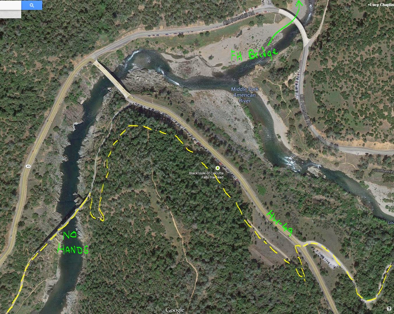
    Trail from parking area at the end of the Quarry Road over to No Hands Bridge


    • At the top of the singletrack, turn right onto a trail on a wide area high above the road. You'll be able to see "new" Foresthill Bridge high above you to the North. 
    • Follow the trail (it narrows) around the point, past the bottom of the Wendell Robie training hill trail, and around a switch back to the right, down to the dirt road leading to No Hands Bridge.
    • Turn left onto the bridge and follow the trail for the next 1.5 miles - it follows an old railroad bed so is mostly wide and flat, but occasionally diverts onto narrow singletrack where old bridges used to cross.
    • (After crossing No Hands Bridge, watch for a trail that goes downhill to the left - you can access the river using this route, should your horse need water.)
    • Approx. 1.5 miles from No Hands Bridge, after dropping down and up through the Black Hole and crossing the creek below the waterfall, the railroad bed comes to an end. Turn right onto the singletrack and follow it to the top. Do not take any side trails. There is a creek and a trough along this section, but both dry out later in the year.
    • At the top, turn left onto the dirt road and, very shortly, at the next split take the uphill trail to the right up to the top of Robie Point (the lower trail to the left goes around Robie Point)

    Robie Point (Mile 98)

    • At the top, at Robie Point, go around the gate/rocks and cross the paved area to another gate immediately opposite. Go around the gate and take the downhill trail. Do not turn left, right, or up the paved road.
    • Follow this dirt track to the bottom of the hill. Just before you reach the bottom, turn onto the sharp right turn.
    • Follow this dirt track - continuing straight when it joins another trail.
    • After approx. 2000', watch for a signed right turn singletrack that goes uphill (the dirt road continues around a sharp bend and goes downhill. Do not take this back down to the river). There may be an old step-over style at the turn onto the singletrack.
    • Follow the singletrack a further 2000'.
    • You'll dip down a short steep incline and up the other side. Towards the top, take the left narrower fork (should be marked WST) which continues level, not the wider right fork that goes up the hill towards the houses
    • Continue on this narrow trail, dropping down through a creek, up the other side and continuing straight when it joins another trail
    • Shortly after it joins this new trail, at the split, take the uphill, right fork
    • Continue on this singletrack to the finish line at the Auburn Overlook


    Tevis Archive

    In 1997 Tevis hit my radar and overnight I was hooked. Being hooked meant that the following year I started doing web coverage (at that time Tevis didn't have any online presence at all, other than people emailing Ridecamp and saying "what's happening?!"). Managing the coverage single-handed was quite an undertaking and basically meant going without more than a few hours sleep from Friday morning through Sunday evening for the next six year's worth of Tevises. Great practice for future 100 mile endurance rides.

    My basic web coverage gradually moved on to me living in Net Control during the ride, listening to the radio broadcasts from the various checks and frantically typing rider # in/out times into my laptop at 3 a.m. (all the while blearily transposing numbers). This segued into setting up and streamlining the more sophisticated "Where's my rider" database system (also used by sister event the Western States 100 Run) conjured up by Richard Goodwin a few years later and still used today.

    Once the database system was in place, it freed me up to be able to go out and take photos and video of the ride - my early web coverage meant I hardly saw a horse during race day, which was not exactly ideal. 
    Archives:
    Past Coverage and Tevis Activities


    Having moved around a lot on the web, many of my early archives have been lost but I dug around and came up with the following. Some are links to overall web coverage of the event, while 2004, 2009, and 2014 cover my personal* posts on the subject.

    (*In 2004 I trained for the ride with Provo and didn't even get to the start line. In 2009 Roo and I made an attempt [which apparently I still have yet to write up. Maybe it'll happen one day - parts of that ride are still crystal clear in my mind] and in 2012 Fergus and I finished. In 2014 Fergus gave me the best ride of my life and one that I'll never forget. Write-up still in progress)


    Wednesday, November 26, 2014

    Tipping into 100 Milers

    So Mike Everett was curious what pushed me into doing 100s.

    Firstly, I should say that like many others, I always had that classic goal of "completing Tevis" - seeing a Cougar Rock photo on a co-worker's office wall is what got me back into horses and into endurance riding in the first place in my early 30s. I didn't start endurance because I had a horse and wanted something to do with it, my whole endurance career was aimed from the very beginning at the elusive Tevis completion.

    But wanting something and getting it are different things.


    I had a rough start to endurance riding - first horse was physically hard on both himself and me (he was always going lame; I ended up needing knee surgery); the second horse had a congenital lameness issue which meant we only did one season and that ended in heartache; the third horse suffered a pasture accident and was never sound again...

    So it wasn't until I got Roo, eight years after starting endurance riding that I really got to settle in and ride 'for real' - at that point I'd only cobbled together about 550 miles and still felt like I didn't have a good handle on what the heck I was doing.

    Roo

    Roo is an excellent little horse: he's uncomplicated, gets on with it, and will travel cheerfully down the trail on a loose rein. His downsides are that he's always had crappy recoveries, he spooks like a devil*, and can be moody as a moody thing** and so most of my 'management issues' with him are mental.

    (* whiplash style - I came off during three successive E-rides, including in the last half-mile of a back-to-back-50 where he should have been tired after 100 miles and I got such a bad concussion—despite the helmet—I didn't even know where my trailer was).

    (** loses complete motivation and slows to a crawl if his ride buddy disappears).

    My biggest "problem" is that I don't ride fast. At one point, I was doing a fine job of managing to come third from last at every single ride I attended (which takes more skill and strategy than you might realise, honest). More recently, I've bumped up to fifth from last... but you get the picture. So long as I finish in the allotted time for the distance at hand, I'm content.

    My reasons for this are twofold - for one, I hate arbitrary time constraints and can't stand being corralled into something time-wise - if this is supposed to be fun, I'll get there when I'm ready; and for another, I don't have the time, stamina, know-how, or desire to do the necessary conditioning needed to top-ten a ride.

    But I always knew that my lack of speed (and lack of ability to get out of a vet hold on time) were going to be a problem if I wanted to finish a 100.


    2007

    In 2007, Roo and I had a stellar year, completing 9 x 50s and a 75.

    I can clearly remember pulling into camp for that 75 and having the weirdest feelings - "finally I'd made it to the big kids!" countered with "I don't belong here and they're all looking at me" (?). But I was so excited that we were going to try the 75. Interestingly, I don't remember ever doubting that we'd finish.

    The ride went relatively smoothly. I rode with a friend so we didn't have any moving forward problems. We got some kinks worked out - had girth rubbing issues so Roo was slathered in Desitin, I neglected to pack enough horse food in my crew bags (who knew he'd eat that much on a 75?), and he got a massive hind-end cramp in the last half mile which scared the heck out of me but resolved itself. As always, we didn't ride fast but we got the job done, finishing near the back in the dark.

    As an aside, I was fine with night riding. We'd practised it four weeks earlier completing the NV Moonshine 50*** ride, coupled with the fact I have a tendency to stay out too late during conditioning rides and end up being caught in the dark.

    (*** NV Moonshine ride starts about an hour or two before sunset so you complete a big chunk of the loop in the daylight before it gets dark - then you ride the same loop backwards in pitch black. Excellent opportunity to find out how you and your horse will do in the dark, not to mention being really fun).

    After Roo's performance at the 75, I honestly think he was ready for a 100, but I didn't know what I was doing. I think in the back of my mind I wanted more proof of his solidity. For some reason, I felt that he had to prove himself at multiday rides before he attempted a 100. Looking back, I don't think this is true, I like my 100-mile horses to have done a back-to-back 50 and I like to have done a 75 so that I know what I'm dealing with, but don't feel the horse has to have completed 3-4 days of 50s in a row to be able to do a 100.


    More Rides

    Later that year, we went to the Tejon ride with the idea of doing all three days and beforehand I fretted that I didn't know enough to know if it was time to stop. As it turned out, the weather conditions were horrendous the second day and I was so pleased with how he dealt with it that I decided we'd done good and didn't ride the third day anyway.

    I promptly messed that karma up three months later when I took him down to Death Valley and tried to do all four days. He was raring to go and it wasn't until the second half of the third day that he settled down enough to ride on a loose rein. We did a good chunk of that day - across the 13 mile dry lake bed - enough to demoralize the best of horses - on our own. At the end of that section, we caught up with some friends at the penultimate vet check and, instead of keeping to our nice steady pace, I kept up with them and rode the last 8 miles much faster than we should have. Coming in at the finish, he was fit to continue but the ride vet said she "saw something" and that we should check back with her in the morning.

    That alone should have been my red flag. If the vet "sees something", "something" is there and it's time to stop. But instead, blinded by my "must do all four days" goal and thinking he just looked funky because we'd come in a little fast, and given the go-ahead by the vet the following morning, I started Day 4.

    Roo felt amazing - I couldn't believe how good he felt after 150 miles as we flew along the trail in the brisk, bright morning sunshine. And about three miles before the lunch vet check he was dead lame in the rear and I hand-walked him in. Lesson learned. I am a dummy.

    (Predictably, he had an almost identical pull the following spring - day 2 of a ride, rode with a friend on a faster horse. Roo got pulled at lunch with a hind-end cramp. OK, so I'm a slow learner.)


    On to 100s

    Two other things were going around that time.

    Patti Stedman "exposed" herself to the endurance world, so to speak, by writing a series of articles in Endurance News chronicling her journey to 100s with Ned. She explained how neither she nor Ned were terribly "classic examples" of 100 mile material, and more or less said "If I can do it, anyone can". (Ned went on to complete 6 out of 7 100s, with Patti on top for 5 of those).

    Bearing in mind my feelings of "OMG, I don't belong up here with the real endurance riders" when Roo and I did that first 75, my brain filed Patti's story away for future consideration.

    Around then I also became friends with Crysta Turnage and her horse, a cobby horse of indeterminate breed named Sinatra. After about 600 miles of 50s, Sinatra and Crysta completed Sunriver as their first 100 in 2006, tried Tevis, messed up on timing and got pulled OT at Michigan Bluff (~65 miles). Crysta did a few more 50s and then, because she lives in icy NV, more or less took the winter off.

    In February 2007, frustrated by the OT pull at Tevis, she decided that they were going to go and do 20 Mule Team 100 in Southern California. Her reasoning  was that she had nothing to lose - Sinatra didn't have a sparkly 100% completion record, so they'd go to the desert and see what happened.

    She wrote up the ride story - including an incident in the dark when Sinatra got itchy while being hand-walked down a hill, lay down to roll (fully tacked up), and got all weebly for a minute when he got back up again. (ctsinatra.blogspot.com/2007/11/twenty-mule-team-100-2007.html)

    But the upshot was they finished. Huh. And she'd hardly ridden him at all that winter?

    Three and half months later, they finished Patriot 100, followed handily by Tevis, followed by an attempt at Virginia City 100 which was thwarted when Sinatra choked at about 50 miles.

    But I haven't mentioned the best part. Sinatra, like Ned and Patti, wasn't "100 mile material". He was built a little on the heavy side, had a high-stepping ("energy wasting", right?) gait, he wasn't fast (his "go along" trot speed was about 7 mph), he wasn't hot (I loved riding with them because he didn't make the horses around him crazy), he wasn't forward or long-legged or an arab... he was just a little cobby-built horse that went along like a metronome.

    And I reasoned if Sinatra and Patti and Ned could finish 100s (and in Sinatra's case, could finish Tevis), why couldn't Roo and I manage a 100? It was time.


    The second part of Crysta's influence was her reasoning for going to 20MT. It taught me to evaluate exactly what I was aiming for in my endurance career.

    • Was it preserving my stellar 100% completion record? Well, like Crysta, I already messed that one up.
    • Was it fear of failure? Perhaps...no-one likes to fail. But where are you going, adventure-wise, if you always do the same repetitive tried-and-tested activities, safe in the knowledge that you'll more than likely finish? Are you growing in any way? Are you pushing yourself in new and interesting directions?
    • Guilt that I might mess up? Well, yes, that was a biggie. In the back of my mind, I wanted to do a 100 "right", I didn't want to somehow mess up and compromise my horse. But in reality, given my slow-poke speed, what's the worst that was likely to happen? We'd go OT (dummy me), he might get pulled for lameness (possible, it is 100 miles, but would it be a career-ending lameness? not likely), he might go into metabolic crisis (why? Provided he was eating and drinking, I would be riding slowly enough that I wasn't going to push him over a metabolic cliff).
    • Fear of the unknown? This is also a difficult one. You don't know how the horse (or you) will react to that distance. You're told the horse will likely "hit the wall" at some point. I fretted that I wouldn't know the difference between "horse is fed up" versus "horse is about to drop dead". But I knew he'd managed 75 miles and was certainly still good to go at the end of that. And once again, you'll never know how your horse (and you) will react to that distance unless you take the plunge and find out.


    Patriot 100

    The best push was Crysta agreeing to chaperone us on our first 100 at Patriot the following year. Nothing better than having someone to hold your hand.

    Once again, I had that "ooooh, I don't belong" feeling pulling into ridecamp. I felt totally sticky-outy, like everyone would be looking and going "they'll never finish a 100" (uh huh... like they have even noticed you exist...).

    I recall parts of the day-time portion of the ride quite clearly. The flowers in the meadow next to the lake; my crew cooking eggs and potatoes for us for "lunch" - although I had no idea what time of day it was; Roo doing a huge spook coming into the mid-day vet hold and me glancing down during vetting and realising he'd spooked himself out of his shoe - it was totally twisted and hanging off (luckily my shoer at the time was also doing the 100 and was in on his hold, and very kindly reset the shoe for me); trotting down endless wooded [dull] fire roads... but the parts I remember most clearly were the nightime portions of the ride - when things got difficult and the amazingness of doing 100s really set in.

    As it turned out, by that time Sinatra was suffering from an aggressive squamous cell carcinoma in his nose and although we thought he was OK, when we got to the 75(?) mile vet check, it became clear that he was done for the day. Roo and I were on our own.

    (Sadly, this was the last ride Sinatra did and he left us the following year.)

    So off Roo and I went, in a bad situation. Roo doesn't like travelling on his own so I had a feeling we were going to be in trouble because of this. But it was still light and there was one remaining rider behind us. We'd see how things went.

    We did pretty well for the first couple of hours - there was a big climb and Roo was willing. Even when it got dark he was still "ok", until he started to see big rocks by the side of the dirt road. And began to spook at them. And worst of all, the trail was taking us away from the vet check and camp. The further we went in the "away" direction, the slower Roo went. No amount of "persuasion" from me could convince him to go faster and we were pretty much down to a slow walk. I didn't get the feeling he had hit the wall so much as his mental powers were just beyond being able to go faster when threatened by a multitude of attack-rocks.

    Finally, the trail turned and we headed south again. Roo's camp radar kicked in and he allowed that, possibly, he could trot afterall. I remember trotting along after midnight in a cloud of euphoria, feeling ridiculously hot (it was a humid night) and poking my t-shirt into my bra to bare my midriff to try and cool off. I remember the trail taking a jog north to drop down to a dirt road below us, and having to be very emphatic that, yes, we would be taking that trail away from camp, albeit briefly. I remember being amazed that he was able to stop dead when detecting tuffs of grass by the side of the trail, despite it being pitch black. And I remember the despair when—once again—he decided he couldn't (wouldn't) trot any more and at this slow walking speed, we would not be finishing our first 100 miler afterall.

    We trudged along in the dark and I came to terms with it. We'd had a good day, Roo had given me a good ride (up until then) and he'd done his best. Neither of us were maimed in any way. It wasn't the end of the world. How many other people were doing something as interesting as this - riding around in the dark, looking out at the lights across the lake, experiencing life to the full? In reality, the whole thing was pretty cool.

    And because we were going so slowly, the rider behind us caught us up.

    It turned out that this rider had been flung into a tree earlier in the day and had broken some ribs, so was understandably unwilling to trot much. Roo cheered up considerably once the other horse caught us. (From later rides when he also threw out the sea anchor when riding alone and wanting horses behind us to catch up, I suspect this had a lot to do with why he was dragging so much.)

    I eventually figured out that if I could get the other rider trotting, Roo would cheerfully trot too and we stood a vague chance of actually finishing the ride. So there started an exercise in psychology - trying to persuade the other rider of "good places to trot".

    The rider announced that they had some glowsticks and would be slightly more willing to trot if we could find some way to attach them to the breast collar. I knew I had tape in my crew box at the vet check, so was happy that we could resolve that problem. Except when we got to the vet check, by miscommunication, it turned out that my crew had taken my crewbox with them and I had nothing at the vet check.

    (This, incidentally, taught me self-reliance - you will need all those bits of string and electrical tape that you stashed in the pommel bag.  :)    )

    We got the glowsticks attached and I was kept awake for the next three hours by virtue of having to regularly use cunning psychology to keep us trotting in fits and starts.

    In the last couple of miles of the ride, as we were making our way through thick, dense, dark woods, I heard some crashing by the side of the trail. Immediately I concluded there was a bear in the woods, the horses were going to spook and dump us and run off, and we'd never finish the ride.

    And then the bear spoke: "Lucy?". It was my shoer who's flashlight had broken and who'd lost the trail in the dark.

    We formed a three-horse procession and came zooming in to the finish (fastest we'd gone in the last four hours) with about ten minutes to spare on the clock.

    And complete we did. I won't say it was pretty, but we got the job done - and had an adventure in the process.

    And I was hooked.