Disclaimer: obviously this is my take on the trail and what needs to be pre-ridden. Other people may have different ideas.
Mileages shown are rough.
Obviously, there's more information on the Tevis website,
including historic notes on the trail by Hal Hall
and an overall map of the entire trail.
including historic notes on the trail by Hal Hall
and an overall map of the entire trail.
Contact the Western States Trail Foundation (WSTF) office
for specific and uptodate details on the trail: 530.823.7282 or wstf @ teviscup . org (close up spaces).
for specific and uptodate details on the trail: 530.823.7282 or wstf @ teviscup . org (close up spaces).
Tevis Trail Pre-Riding:
You mostly split the trail into three sections:- Robie Park to Red Star Ridge/Robinson Flat (Mile 0 to 28/36)
The High Country - no pre-riding needed - Robinson Flat to Foresthill (Mile 36 to 68)
The Canyons - some pre-riding needed so your horse knows what’s coming. - Foresthill to Finish (Mile 68 to 100)
CA-Loop singletrack - most of your pre-riding will be here.
1. Robie Park to Red Star Ridge (Mile 0 to 28):
I have never pre-ridden this section and I don't really think it's worth the trouble, frankly. Moving rigs is all but impossible unless you have a really helpful assistant who’s willing to drive you up to Tahoe, then drive all the way to Robinson Flat to meet you = a very long boring day for them. I was happy to have this part of the trail as a surprise (I adore the Granite Chief Wilderness Section and it was lovely to see if for the first time "on the ride"). Water is limited (some at the beginning near Squaw and in Granite Chief Wilderness, but none from Lyon Ridge to Robinson Flat)That said, if you do want to pre-ride parts of it:
Robie Park to hw89 (Mile 0 to ~6)
Park: at Robie Park (very long slow drive in), ride the trail to hw-89 and return.
Or park in the turnout at hw-89 (see blue arrow on map below) and ride up to Robie Park and back.
Trail: I don't believe this trail is marked "to Robie"/"WST", so you'd need to follow GPS. There are turn-offs, so not self-explanatory. There are two sections with some short, low wooden bridges that cross boggy areas. These shouldn't be a big deal for a seasoned trail horse.
Water:
- Not a lot of water on the trail - a couple of small trickles earlier in the year.
- You might be able to slither down to the river at hw-89 with a bucket.
- There is a water pump at Robie Park.
Your horse is so hyped and everything is such a blur and it's dark for the first 15 mins or so, and you're in the long train of riders so it's not like a) you could get lost or b) you see much, or c) you can really control speed much. So all in all, not worth the trouble.
The only thing probably worth doing on pre-Ride Friday is to ride up to the start and go the first couple of 100 yrds down the trail to familiarise you with the route. Do this as a leg-stretcher pre/post vetting. Also inspect whichever pen you're going to be in. It's very very dark on Saturday morning and there are tree stumps etc to trip over, so it's good for you and your horse to at least know that part.
 |
| Map showing the trail where it “crosses” hw-89. The trail goes under the road next to the bike path then goes alongside the south side of the road behind the barrier over the river on the bridge. Park in the turn out indicated by the blue arrow. Or just visit there and inspect the trail layout on foot. |
Hw-89 to Bottom of Squaw (Mile ~6 to 8):
Park: at the HW-89 turnout (see blue arrow on map above) and ride the trail west along the ridge south of Squaw.
Alternatively, park in the parking lot at Squaw and access the trail from there (I have never done this, but believe it's perfectly legal).
Trail: This trail *may* be marked "WST", but I'm not 100% sure. Probably need to follow GPS. There are turn-offs, so not self-explanatory.
Water: There is at least one creek crossing about half-way along for horse water
(can’t remember exactly – I’ve put a couple of lil blue crosses where I think it might be, ish):
 |
| Map showing Hw-89 Crossing to the Climb in Squaw Valley |
Squaw to Red Star (Mile 8 to 28):
Park: at Squaw Valley.
It's probably worth checking with the WSTF office (530.823.7282 or wstf @ teviscup . org [close up spaces]) regarding this stretch of trail, as I'm not sure about the actual legality of riding across Squaw Valley property.
Note from a friend: "Squaw is private property and the trail access is somewhat of a "as long as you're not in the way" type of thing. I know the actual riders have to sign a release form in order to cross the property (in the pre-ride packet)."
A couple of years ago they were doing work on the westerly ski-slope area and didn't want people going in there because of construction equipment, etc. Don't know if this still holds true, but worth checking. For example, during the ride, we had to cross over some straw-berm-things that seemed to be covering electrical cables. One horse in steel shoes (ridden by Hal Hall) trod on the berm and got an electric shock (transferred to the rider). So take care.
Trail: Provided you can access the trail through the Squaw Valley resort, you can follow the trail all the way to Red Star and Robinson Flat.
This trail *may* be marked WST, but is not self-explanatory and there are turn offs, so again, GPS track needed.
Water: There is water along the way in Granite Chief Wilderness, but nothing along Lyon Ridge (very dry). Allegedly there is a spring at Red Star, but we looked for it a couple of years ago and didn't find it.
2. Red Star Ridge to Foresthill:
Red Star to Robinson Flat (Mile 28 to 36):
Park: at Robinson Flat. Camping is free overnight with horses. They have a pit toilet and a hand-crank pump in the meadow for horse water.
Trail: This is basically a hard-packed dirt road for 8 miles. Not worth riding, but if you’d like to see it, unhitch your truck and drive it. There are some pretty views and the road is rough (but they get trailers in there, so not awful). You need to be aware of one turn-off (left [north], going backwards up the “trail”) close to Red Star (see grotty map below).
Water: None (except for the elusive Spring north of Red Star that we didn’t find).
 |
| Really grotty map, showing the Red Star Ridge Vet Check Area: Red = Red Star Vet Check (wide spot in road, sort of four-way intersection). Yellow = Tevis Trail (west goes to Robinson Flat, East goes (eventually) to Cougar Rock) Blue = Road you need to turn off of. The road from RF continues on this blue road. Turn left to go to RS Green = Soda Springs Road – the road goes from Robinson Flat all the way to Soda Springs. Very rough past Red Star Vet Check (also shown in green, spur road west of RS) |
Robinson Flat to Foresthill (Mile 36 to 68):
Park: at Robinson Flat. Camping is free overnight with horses. They have a pit toilet and a hand-crank pump in the meadow for horse water. Fire rings, picnic tables…
Our usual MO is to pick a weekend in June and go up there on Friday and camp, and then ride from RF to FH in one go (32 miles) on Sunday.
Alternatives:
- Only ride as far as Last Chance. Bad idea – paved road from Foresthill to Last Chance takes HOURS. Very very twisty. Last few miles is dirt.
- Only ride as far as Deadwood, then ride the 8 miles out on DW Road to paved Foresthill Road (a long dirt road, probably not worth the trouble, but an option with a lame horse)
- Only ride as far as Michigan Bluff – avoid the final Volcano Canyon. Again, not usually worth the trouble – it’s much easier to park a trailer/support vehicle in Foresthill, than to drive down to MB – and it’s only another six miles from MB to FH. Volcano Canyon is the smallest one.
As far as trailer-pooling, there are two ways:
- Leave a car in Foresthill (near the school?) on the way past. Then get a really kind friend to drive your rig to FH after you’ve departed and leave it for you in FH and they go home in the car
- Leave a car in FH on the way past. Then have at least two more riders than there are trailers. When you arrive in FH, one person stays with all the horses (we cache horse food and water beforehand), while the other two take the car to go and fetch the trailer at RF. This makes for a very long day, esp. if you leave late to start with, but is perfectly doable.
Camping for the weekend: there’s a really pretty 5 mile loop out of the RF meadow that takes you up the ridge to the south of RF – excellent views - and you can visit the Look Out Tower (the ranger is very nice and likes visitors) to look over towards Foresthill. You come back down to the meadow on an alternate Tevis trail (last used in 2009?). It’s a nice place to camp for a couple of nights prior to your Big Preride.
 |
| Map showing Robinson Flat Vet Check/Camping Area |
Water: The longest waterless stretch is from Robinson Flat to Last Chance ~14 miles. If it’s ridiculously hot, we have cached water (in gallon ziploc bags so we could stuff them in the saddle bags when empty) at the turn off to Dusty Corners which is accessible by vehicle from Robinson Flat.
Otherwise, there is water at:
- Robinson Flat (hand-operated pump in meadow)
- Last Chance (spring w. small trough)(this water is very cold so take care they don’t drink too much too quickly)
- on the way to Swinging Bridge (small creek)
- below SB (river)
- just past SB (small creek)
- at Deadwood vetcheck (hand-pump)
- a few miles out of DW (Kaputt Springs)
- at El Dorado Creek in bottom of Canyon (see details below)
- on the way up to Michigan Bluff (small creek)
- at MB (at least sometimes – a trough outside the Hall’s house)
- at Volcano Creek in bottom of Canyon (small creek. Can run high and fast earlier in the year)
Trail: This trail is mostly marked WST, but can be confusing in places.
Difficult turns to spot/areas:
- Turn off to Dusty Corners (DC) (easy to miss)
- Turn off to Pucker Point (easy to miss)
- Trail when you reach Devil’s Thumb (confusing multiple routes)
Robinson Flat (Mile 36)
- Hard-packed gravel road from RF to turn off (right) to DC (gradual downhill)
- Dirt road to short stretch of gravel road to DC (mostly flat)
Dusty Corners (Mile 45)
- Very narrow singletrack Pucker Pt trail (mostly flat)
- Beware of free-range cows on the Pucker Pt trail
- Right turn onto gravel road to Last Chance (slight downhill)
 |
| Trail around Dusty Corners |
Last Chance (Mile 50)
(Last Chance to Devil’s Thumb = Canyon #1 - Swinging Bridge Canyon/also known as Deadwood Canyon. Deepest):
- There is an old mining cabin on north side of gravel road. Just past the mining cabin, there is a wide area in the road and some interpretive signage. Below the road, down a short steep bank (~15’) is a little meadow. The spring was on the far side of the meadow.
- Continue on gravel road past Last Chance, past old mining machinery. Gravel turns to dirt. Go around a bar-gate, trail veers around downhill to the right. At the end of this stretch used to be Pacific Slab mine (old mining buildings, interpretive signage). I know this burned. : ( Tevis trail breaks off to the left onto singletrack shortly before you get to the end.
- Follow very narrow singletrack down, down, down. There is one small (tiny) creek crossing, and you will cross over a small (newly rebuilt after the fire) bridge… down down down down to Swinging Bridge.
 |
| Trail around Last Chance |
Swinging Bridge (Mile 52)
- Two options:
- Cross newly rebuilt Swinging Bridge, or
- Take the trail to the left down to river. Swinging Bridge is above you, to the right. Look across to the far bank (slightly to the right of opposite) and you'll see an access point on the far bank. Take the rocky trail and rejoin the normal trail.
- Small creek on trail after Swinging Bridge.
- Very narrow singletrack up up up up up up up up upupppp upupupupupupu – 27 million switchbacks. This is the trail your horse needs to have seen ahead of time – it can be very demoralizing because the climb goes on and on and on. The horse needs to know “this too shall pass”.
- Cross newly rebuilt Swinging Bridge, or
- Take the trail to the left down to river. Swinging Bridge is above you, to the right. Look across to the far bank (slightly to the right of opposite) and you'll see an access point on the far bank. Take the rocky trail and rejoin the normal trail.
Devil’s Thumb (Mile 54)
 |
| Trail around Devil’s Thumb |
- Arrive at top – having passed Devil’s Thumb rock outcropping, just visible through the trees on your left.
- Continue across open area, cross over dirt road and take the small trail that starts slightly downhill - through the non-burned area. This is the end of the 2013 burn.
- Follow singletrack/dirt road to Deadwood vet check area (open area on main dirt road).
Deadwood (Mile 56)
(Deadwood to Michigan Bluff = Canyon #2 - Eldorado Canyon, Medium):- There is a hand-pump here for horse water and picnic tables. This hand pump water has been tested and "should" be human potable. Check with WSTF office to be sure this is still current.
- Follow dirt road to left. The trail is sometimes on the road, sometimes 20-30' to the east of the dirt road.
- At end of dirt road there’s an open area (old Cemetery directly in front of you). Singletrack trail veers off to the left.
- Follow singletrack/dirt track trail, it crosses another trail – should be marked WST.
- Then drops downhill on a very narrow singletrack goes down into canyon with switchbacks, past Kaputt Springs.
- Eventually arrive at El Dorado Creek bridge. Cross over bridge and follow trail straight, then shortly veering to right onto flat dirt track.
- WST turns left uphill onto a singletrack. Continue up, up, up on singletrack. It crosses over the dirt track a few times.
- (If you need water at this point, instead of turning onto the uphill singletrack, continue north on the flat dirt track for a few hundred yards and there’s a lil’ turn off into the bushes on the right – creek access for horses there (little creek that runs into larger El Dorado Creek))
- Backtrack and continue up on narrow singletrack, you’ll cross one more creek towards the top.
- Singletrack exits onto dirt road next to large brown sign. Go straight, past the houses, around the bar gate into Michigan Bluff.
Michigan Bluff (Mile 62)
- Turn right on paved road through MB “town”. Gary and Judy Hall’s house is on left half-way down. Trough is on corner.
- Continue through town. Just before the road starts up the hill, there’s a left turn onto a gravel road. “Gorman Ranch Road”.
- Follow gravel/dirt road. After ~1.5 miles, turn off dirt road up hill on Chicken Hawk Road (DO NOT GO STRAIGHT).
- Continue up dirt road ~0.75 mile to Chicken Hawk VC area - signed as as Chicken Hawk Staging area (Chicken Hawk Road continues on and rejoins Michigan Bluff Road)
 |
| Map showing trail between Michigan Bluff and Chicken Hawk Vet Check |
Chicken Hawk (64)
(Chicken Hawk to Foresthill = Canyon #3 – Volcano Canyon, Smallest):
- Chicken Hawk Staging Area is a wide open area. When you reach the open area - look directly across and you'll see the entrance to a new singletrack trail. Take this twisty singletrack to the bottom (~0.5 mile)
- At the bottom, go straight/left on the dirt track a short distance to the next intersection. Turn right onto the dirt track.
- Go ~500' and keep an eye out for WST signs - bear right off main trail
- Follow the trail all the way to the bottom of the Canyon and cross Volcano Creek (take care during high flow)
- Continue up the other side on singletrack. When the trail opens up, continue up a section of baby heads and eroded chalky trail. Pass an open bar gate. Trail eventually exits at the foot of paved Bath Road
- Go around bar gate onto Bath Road and follow it to the top and turn left into Foresthill Mill Site.
3. Foresthill to Finish (Mile 68 to 100):
Foresthill to Poverty Bar (Mile 68 to 88):
Park:
- in front of the cemetery between Bath Road and the School in Foresthill.
- at the school as you exit Foresthill towards Bath Rd
- on Lowe Road (after you go down California Street) on the south verge, provided locals don’t object (I seem to remember the ones that weren’t happy posted signs on their fences to not park there).
- with a dedicated driver, drop a car at Driver's Flat Road on your way through. Drive the horses up to Foresthill, send the horses and riders on their way, then dedicated driver drives the rig back down to Driver's Flat Road and picks up the car.
- no dedicated driver? with three riders, leave a car at Driver's Flat on the way past. When you arrive at Driver's Flat after riding, one rider stays with three horses (ideally cache water/food ahead of time), while the other two riders take the car to fetch the rig in Foresthill.
- a little ways down bumpy Driver’s Flat Rd - this is better for the horse, but they’ve had some truck break-ins the last few years, so beware.
- Safer for your vehicle, but more open and exposed to traffic (and requires you to cross Foresthill Rd) is along the turnout on Foresthill Rd. It’s not bad.
Trail: Is marked for the most part. The tricky areas are at the start just after you leave the town of Foresthill, plus there are a couple of turns at Peachstone (Cal-2) and at Ford’s Bar (more on this below). And the area around Francisco’s, while actually straightforward, isn’t self-explanatory
Water:

Trail:
This next section is really the only strange and not-obvious part of the whole trail:
Scree-Face
You can, however, ride it as a short 12 mile round trip out and back from Driver’s Flat parking area. This is excellent training for your and your horse's quads and I usually do it a couple of times in the lead up to the ride - the last time ideally within two weeks for maximum quad strengthening. This will really make a difference on ride day if you plan to hike down the canyons - you won't suffer from jelly-legs or super-tight quads nearly as much. The climb back up Driver's Flat is not to be sniffed at either - 1000'+ in 1.75 miles.
Note that Driver’s Flat Road is the access road for the rafting companies and the campground, so there can be some traffic on it - i.e. minivans with rafts strapped to the roof. The road is somewhat narrow, so keep to the "up" side when vehicles pass. They are usually very polite and go slowly (the rutted road doesn't allow for much speed).
Pre-riding Alternative - Riding from Driver's Flat to Finish:
Park: at Driver's Flat.
Water: at the river crossing.
Trail:
Water:
- a couple of small creek crossings in the Dardenelles vicinity
- a small creek crossing towards the end of Cal-1
- a small trough towards the end of Cal-1
- Turn left (off trail a short distance) at the bottom of Ford’s Bar and go down to the American River
- a creek crossing at the bottom of the switchbacks below Peachstone/Cal-2
- a small creek crossing in Sandy Bottom
- a ford nearly at Francisco’s (dries up as it gets hotter)
- a creek crossing/ford just after Francisco’s (dries up as it gets hotter)
- (if desperate, you can access the river below Francisco’s where the WS100 runner’s cross/boat launch)
- Poverty Bar river crossing
This section is divided up into Cal-1 and Cal-2.
A few miles further on, you’ll pass a wooden platform by the side of the trail with a big brown sign. I tend to think of this as being the “official” start of Cal-1.
Cal-1 ends at the wide spot in the trees (“Peachstone” –named for Peachstone Gulch – not everyone knows this name and some just call it Cal-2).
Cal-2 runs down through the switchbacks to Ford’s Bar.
I have heard the area between Ford’s Bar and Francisco’s occasionally known as “Cal-3”.
- Cal-1 is from Foresthill to Peachstone
- Cal-2 is from Peachstone onwards, but those designations are a little vague.
A few miles further on, you’ll pass a wooden platform by the side of the trail with a big brown sign. I tend to think of this as being the “official” start of Cal-1.
Cal-1 ends at the wide spot in the trees (“Peachstone” –named for Peachstone Gulch – not everyone knows this name and some just call it Cal-2).
Cal-2 runs down through the switchbacks to Ford’s Bar.
I have heard the area between Ford’s Bar and Francisco’s occasionally known as “Cal-3”.
This trail is very narrow in places with drop-offs, so (obviously) care should be taken.Green horses not recommended.There are few places to pass, particularly in the dark on Ride Day.
 |
| California Street trail access |
- Follow Main Street (frontage road in Foresthill) and turn left on California Street.
- Go a block and turn right on Lowe St and follow it around to the left. Go to the end of the pavement.
- Go through the gap in the fence, down a short embankment and cross Mosquito Ridge Road.
- Trail starts here.
This next section is really the only strange and not-obvious part of the whole trail:
- Follow the singletrack through a switchback then drop down onto a flat area (less than 0.5 mile) at a dirt road (see red dashed line on map below)
- Turn sharp left on the dirt road and follow it around the left curve.
- Take the next right turn (looks like a yellowy-white track)
- Go about 800' and make a hard right down a chalky eroded track (blue dashed line – see below)
- You are now on the singletrack trail which continues for the many miles
 |
| Trail between California Street and singletrack. |
Dardenelles (Mile ~71)
- The trail continues for the next ~2.25 miles deep under the trees, in a steep sided canyon, and through Dardenelles Creek a couple of times.
- Recommend pre-riding this portion of the trail because it is very, very dark under the trees and depending on timing, this will possibly be the first place you will be really riding in the dark.(crossing Mosquito Ridge and going onto the dark trail in 2012 [overcast, so no moon], for me, was one of the only times in the whole ride I thought maybe I’d bitten off more than I could chew. “This is *REALLY* dark” I told Fergus. We were absolutely fine, but it took some getting used to).
Scree-Face
- Approximately 3 miles after you’ve left the lights of Foresthill, there’s an odd jog in the trail - the singletrack comes out onto a scree-face. You slither down the scree-face ~30', then pick up the trail again (there’s some kind of hydro-electric thingy at the foot of this scree-face, down on the river).
Cal-1 (Mile ~73)
- Another 1000' or so along the trail, you’ll see the small wooden platform by the side of the trail and the big brown sign. This is where I think of Cal-1 as starting.
- Within another half a mile, there will be a short-but-very-steep climb up some switchbacks, only to drop back down again almost immediately.
- This is the only climb of any significance until you reach Ford’s Bar.
- Follow the singletrack along the canyonside (high above the river) for a further ~5 miles (approx. 8 miles after leaving the lights of Foresthill).
- You will go through at least one small creek crossing, and there’s also a green pond-weed-filled trough by the side of the trail (horses never seem to drink from this trough).
- Finally you will exit the trail in a wide spot – it’s the intersection of three trails/dirt tracks. This is “Peachstone” or the start of Cal-2.
Peachstone/Cal-2 to Francisco’s (Mile 79 to 85)
- On ride day they have water troughs here, as well as hay and a number-taker. It can be a little crowded.
- Although they don't have a vet at this location, it is possible to pull your horse here (although this necessitates quite a long uphill-walk of approximately 1.5 miles to get to pavement where a trailer can pick you up. Not ideal, but possible).
Switchbacks
 |
| Switchbacks below Peachstone/Cal-2, showing creek location |
- Take the left/downhill split in the trail and follow the trail down a series of 6+ loooonggg switchbacks
- The trail then levels out for approx.. 1000' and there’s a creek crossing
- Follow the singletrack for a further 0.7 mile and you’ll exit onto a steep dirt road. This is Ford’s Bar.
Ford’s Bar (Mile ~81)
 |
| Trail at Ford's Bar. Take the switchbacks up the hill (red line). For water access, drop down the trail to the river (blue line) |
- (If you follow the steep dirt road down the hill (blue line – see above), the river is only ~300’ below you. There is a nice shallow gravel bar there and you can take your horse into the river to cool off.)
- The trail, however, goes up this steep hill. This is where hot horses can get miserable as the climb is steep.
- Follow dirt road uphill; right; continue uphill, left; continue uphill; then stay straight until you reach the top (there is a big brown WST mileage sign here and there are very welcome troughs here on ride day).
- Continue straight and start to work your way back down the hill. This is also a dirt track.
- Follow the dirt track ~2000' down until you turn onto a singletrack that veers to the right and slightly uphill. Watch for WST signs.
- This next section is very narrow exposed singletrack with a drop-off. Follow this singletrack trail.
Sandy Bottom (Mile ~83)
- Eventually the singletrack drops down to river level (although not accessible) and opens up somewhat – the area is very green, lush, and shady, with sandy footing. This is Sandy Bottom.
(Sandy Bottom is one of the only places along the trail that absolutely cannot get radio signal, so do not break your leg here). - There is a small creek crossing along here where you can sponge
- Continue along the trail, past some rock faces, the trail narrows again, but eventually exits onto a hard-packed grey dirt road that veers uphill. This is the River Road.
River Road (Mile ~84)
- Follow the river road, continuing downstream. Below you are the Rucky Chucky Rapids
- You have a step-over at one pole gate (they must open the gate on ride day, because I don’t remember it being there in the dark)
- You pass through a few camp sites with bear boxes.
- You pass through a concrete ford that will probably be dry
- After ~1.5 miles, you’ll come to a red dirt road that veers uphill – you have to go around a metal gate.
- Follow this red dirt road gradually up the hill for ~1000'. At the top is a round meadow with a picnic table. This is Francisco’s.
- (If you are desperate for water, instead of turning uphill around the gate, you can continue on the river road (blue dashed line – see below) to the area below Francisco’s. This is the main campground area (pit toilets, parking) and there are a couple of places/boat ramps to access the river (this is where the runners cross the river during WS100 Run). You can continue along the river road out the other side until you come to a concrete ford (dries up later in the year). This is where you rejoin the Tevis trail)
Francisco’s (Mile ~85)
- To continue on the trail, exit Francisco’s meadow via the narrow singletrack on the west side, descend to the bottom, cross the creek (water here in spring only) and reach the dirt road (Driver’s Flat Road).
- Continue right up the dirt road – up the hill to Driver’s Flat staging area if that is your final destination on this outing. The climb back up Driver's Flat is 1000'+ in 1.75 miles.
- If you intend to include the trip out-n-back (approx. 6 mile round trip) to the river crossing at Poverty Bar on this outing, as you climb up Driver's Flat Road, look for a narrow singletrack trail on left after ~1250'. This tiny track is the WST and is signed, but hard to spot if you're not looking for it.
 |
| Trail system around Francisco's |
- (A bit of history: the yellow line/arrow shows the route up to White Oak Flat (at the end of McKeon-Ponderosa Road) which was an alternate route used by Tevis in past years. Instead of going down at Peachstone, you went up, followed a complicated trail through the now built-up area of Todd’s Valley, before finally coming to the vet check at White Oak Flat and then descending to Francisco’s. This route has been abandoned mostly because it is too dangerous with traffic in Todd Valley. Last time it was used was in the late 90s).
Francisco’s to River Crossing (Poverty Bar) (Mile 85 to 88)
This section is usually pre-ridden at the end of riding the CAL Loop section, before ascending Driver's Flat Road to the top. However, on a hot day when you're tired, despite the best intentions, it’s often skipped.You can, however, ride it as a short 12 mile round trip out and back from Driver’s Flat parking area. This is excellent training for your and your horse's quads and I usually do it a couple of times in the lead up to the ride - the last time ideally within two weeks for maximum quad strengthening. This will really make a difference on ride day if you plan to hike down the canyons - you won't suffer from jelly-legs or super-tight quads nearly as much. The climb back up Driver's Flat is not to be sniffed at either - 1000'+ in 1.75 miles.
Note that Driver’s Flat Road is the access road for the rafting companies and the campground, so there can be some traffic on it - i.e. minivans with rafts strapped to the roof. The road is somewhat narrow, so keep to the "up" side when vehicles pass. They are usually very polite and go slowly (the rutted road doesn't allow for much speed).
Pre-riding Alternative - Riding from Driver's Flat to Finish:
- with a dedicated driver, drop a car at Auburn Overlook/finish line on your way through. Drive the horses up to Driver's Flat, send the horses and riders on their way, then dedicated driver drives the rig back down to Finish and picks up the car.
- no dedicated driver? with three riders, leave a car at Auburn Overlook/finish line on the way past. When you arrive at Finish after riding, one rider stays with three horses (ideally cache water/food ahead of time), while the other two riders take the car to fetch the rig at Driver's Flat.
Park: at Driver's Flat.
Note: Driver's Flat Road is a fee area. There are two parking opportunities at Driver’s Flat (see blue areas on map below):
- a little ways down bumpy Driver’s Flat Rd - this is better for the horse, but they’ve had some vehicle break-ins the last few years, so beware.
- Safer for your vehicle, but more open and exposed to traffic (and requires you to cross Foresthill Rd) is along the turnout on Foresthill Rd. It’s not bad. Follow trail (red dashed line) to access Driver's Flat Road (yellow dashed line).
 |
| Parking at Driver's Flat (blue areas). Take red dashed route to get to the lower parking area by trail. Follow yellow dashed route to go down to Franscisco's and WST |
Trail:
- Follow the dirt road through lower Driver's Flat staging area, through the yellow gate (believe the sign mention campground/river access) (see yellow dashed line on map above). It starts easy and gradually gets steeper.
- Continue downhill for 1.75 miles and watch for signed right turn onto narrow singletrack (almost doubles back on dirt road)
OR - From Francisco's - after exiting the meadow/vet check area on the narrow singletrack on the west side, cross the rocky creek (water here in spring only) and turn right onto the dirt road, uphill
- Continue up the dirt road for 1250' and look for a narrow singletrack branching off to the left.
- Follow singletrack for approx. 3 miles until you come to the sandy flat area at river level.
- Continue across sandy flat area on double track to access an opening to the river downstream.
- Cross the river
River Crossing (Poverty Bar) to Finish Mile 88 to 100)
Care should be taken crossing the river. Riders and horses have been swept downstream into the rapids trying to cross here in the afternoon when the river level was high, so please take extreme care and avoid crossing if it seems too deep.
On ride day, they lower the level of the river by limiting the outflow from dams upstream.
On normal days, the river level fluctuates, but they typically increase the flow in the afternoon. When pre-riding, you should ideally try to cross before noon to ensure the river isn't too deep.
 |
| River Crossing. Take the red dashed line option for shallowest crossing. |
The water is deeper the further upstream you go, so try to cross using the red-dashed line route (shown on the map above) across to the shallower far bank, before looping towards the opening in the trees/bushes to access the trail.
Pre-riding Alternative:
Ride as an out and back from the Overlook finish line - ~22 miles round trip.
The Overlook staging area is now controlled by the WSTF and a donation of $5 is requested.
Water:
- River crossing at Poverty Bar
- Creek just west of Maine Bar (dry in summer)
- Creek at Browns Bar (dry in summer)
- River access approx. 2.5 miles downstream from Maine Bar
- Creek crossing between Browns Bar, closer to Lower Quarry (dry in summer)
- River access below No-Hands bridge
- Creek crossing in Black Hole
- Creek crossing on singletrack leading up to Robie Point (dry in summer)
- Trough on singletrack leading up to Robie Point (often dry in summer)
- Water trough and water faucets at Overlook Finish line.
Trail:
- Once you have crossed the river, look for an opening in the bushes/trees on the south side of the river.
- Take the singletrack that veers sharply uphill. Stay on this trail, ignoring several left turn options.
- Stay on singletrack for approx. 0.5 miles
- When it exits in an open area, turn right downhill. This is Maine Bar.
 |
| Maine Bar. Follow yellow route for WST. Picnic tables are to be found on east end of Maine Bar. |
- At the bottom of the hill, turn left onto the wide trail and follow this trail downstream.
- After approximately 1 mile, take the left uphill fork (narrower than old trail). This short section was built as a bypass to avoid an area of very eroded riverbank.
- This bypass exits back onto the dirt track to the left.
- Continue on this dirt track for approx. 1.5 miles, following river downstream
- At this point, you are almost at river level and can access the river to allow your horse to drink. Watch for narrow deer-track-like routes through the large rocks to get to the river.
- Continue on the dirt track for a further 1.5 miles. You will pass some concrete bunkers and the entrance to a gated cave on your left (south), and then, ignoring side turns, drop downhill past some large concrete old bridge abutments on your right (north).
- At the bottom of this hill, if you look to your right (upstream), you will see Lower Quarry vet check area (there are picnic tables and shade covers in this flat area).
Lower Quarry (Mile 94)
- Continue downstream on the hard gravel road next to the river for approx. 1 mile, until you reach a locked gate and a parking area.
- Cross the road (hw-49) at top of parking area and take the singletrack up the other side.
- Take care crossing the paved road on shod horses - the pavement can be slippery and traffic speedy.
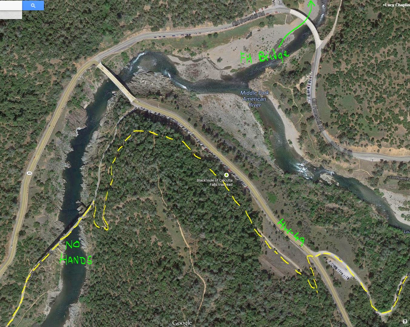 |
| Trail from parking area at the end of the Quarry Road over to No Hands Bridge |
- At the top of the singletrack, turn right onto a trail on a wide area high above the road. You'll be able to see "new" Foresthill Bridge high above you to the North.
- Follow the trail (it narrows) around the point, past the bottom of the Wendell Robie training hill trail, and around a switch back to the right, down to the dirt road leading to No Hands Bridge.
- Turn left onto the bridge and follow the trail for the next 1.5 miles - it follows an old railroad bed so is mostly wide and flat, but occasionally diverts onto narrow singletrack where old bridges used to cross.
- (After crossing No Hands Bridge, watch for a trail that goes downhill to the left - you can access the river using this route, should your horse need water.)
- Approx. 1.5 miles from No Hands Bridge, after dropping down and up through the Black Hole and crossing the creek below the waterfall, the railroad bed comes to an end. Turn right onto the singletrack and follow it to the top. Do not take any side trails. There is a creek and a trough along this section, but both dry out later in the year.
- At the top, turn left onto the dirt road and, very shortly, at the next split take the uphill trail to the right up to the top of Robie Point (the lower trail to the left goes around Robie Point).
Robie Point (Mile 98)
- At the top, at Robie Point, go around the gate/rocks and cross the paved area to another gate immediately opposite. Go around the gate and take the downhill trail. Do not turn left, right, or up the paved road.
- Follow this dirt track to the bottom of the hill. Just before you reach the bottom, turn onto the sharp right turn.
- Follow this dirt track - continuing straight when it joins another trail.
- After approx. 2000', watch for a signed right turn singletrack that goes uphill (the dirt road continues around a sharp bend and goes downhill. Do not take this back down to the river). There may be an old step-over style at the turn onto the singletrack.
- Follow the singletrack a further 2000'.
- You'll dip down a short steep incline and up the other side. Towards the top, take the left narrower fork (should be marked WST) which continues level, not the wider right fork that goes up the hill towards the houses
- Continue on this narrow trail, dropping down through a creek, up the other side and continuing straight when it joins another trail
- Shortly after it joins this new trail, at the split, take the uphill, right fork
- Continue on this singletrack to the finish line at the Auburn Overlook.
No comments:
Post a Comment